
Bay Trail Information
LGVSD Trails Offer Hiking, Biking, Views and More
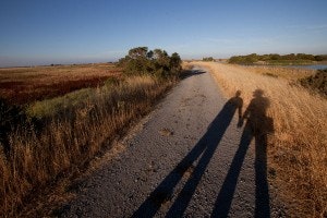
At the Las Gallinas Valley Sanitary District Treatment Plant, four miles of public trails are open to walkers and cyclists. There they can enjoy wildflower displays, bird and wildlife watching, and the serenity of unobstructed views of San Pablo Bay and its surrounding hills and wetlands.
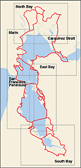
The District’s trails connect to the Bay Trail, which is a planned recreational corridor that, when complete, will encircle San Francisco and San Pablo Bays with a continuous 500-mile network of bicycling and hiking trails. It will connect the shoreline of all nine Bay Area counties, link 47 cities, and cross the major toll bridges in the region. To date, approximately 310 miles of the alignment—over 60 percent of the Bay Trail’s ultimate length—have been completed.1
Our 383 acre reclamation area includes 200 acres of pasture irrigation fields, two treated wastewater storage ponds and a freshwater pond with three islands that are popular with nesting birds. The area provides homes for wildlife and migrating and resident birds including raptors, blue herons, clapper rails, egrets and pelicans.
1: Source: www.baytrail.org
To see how LGVSD paths relate to the San Francisco Bay Trail system, please visit the Bay Trail website which includes interactive maps.